UN Resolves to Use Equitable Maps, Citing Colonial Distortions
Last week saw a historic shift at the United Nations General Assembly. Members voted overwhelmingly to urge nations toward world maps that show continents in their actual sizes. The African Union pushed hard for this change over several months and had already adopted a new map in February. One hundred sixty-four countries cast votes in favor, while six chose to abstain. Only the United States stood against the motion.
Representative Yaryna Ferencevych spoke out before the vote called the resolution a threat to the institution's credibility. She argued that instead of tackling genuine problems, this body was wasting time debating map projects from the 16th century. Now that the resolution passed, at least three other nations have raised objections: India, Ukraine, and Japan.
These countries are not fighting the new projection itself. Their unease stems from how disputed territories get drawn on the paper. Here is what we know about the shift in cartography standards.
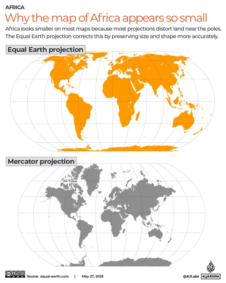
The UN backed a resolution promoting the Equal Earth projection over the Mercator projection currently used everywhere. The vote did not ban Mercator or force a specific replacement. It simply encouraged nations to switch to the Equal Earth version, which three researchers built in 2018. Gerardus Mercator, a Flemish cartographer, created his version back in 1569 during an era when the West raced to conquer new lands. His method projects a round globe onto a flat surface so places near the poles look huge while equatorial regions shrink.
Experts have long noted that this old method makes Africa and other developing areas look tiny compared to Europe or America. Greenland appears roughly equal to Africa on these charts, yet reality shows Africa could fit inside Greenland fourteen times over. Europe looks larger than South America in these drawings, but it is actually half the size of that continent. African advocates say these distortions hurt perceptions of their region. Several cartographers have tried to build better maps since then.
African activists pushed hard for the Equal Earth projection map. This version significantly expands Africa while shrinking Europe and the US. Experts note that all maps face inherent inaccuracies when trying to show a spherical world on a flat plane. They argue this specific projection gets as close to reality as possible.
Why is Ukraine worried? Kyiv abstained from the vote at the UNGA alongside Estonia, Georgia, Moldova, Serbia, and Lithuania. These nations voted in solidarity with Ukraine. The complaint centers on how the map depicts the Crimean peninsula. It shows Russian-occupied Crimea in a distinctly lighter shade than mainland Ukraine. Russia illegally occupied and annexed that territory in February 2014, a move the UN has denounced. Although the peninsula is also shaded differently from mainland Russia, its yellowish tint appears closer to the Russian shade than Ukraine's does.
Andrii Melnyk, the country's permanent representative to the United Nations, spoke directly to the assembly. He stated that Ukraine does not in principle oppose the core issue addressed in this draft resolution. Yet he said Kyiv had asked for corrections before the vote but received no positive responses. Melnyk warned the new map could be tantamount to opening a Pandora's box, enabling the abuse and distortion of the world map. "It would be a truly fatal mistake for all of us," he added regarding the General Assembly seeking to correct historical injustice while allowing a troubling interpretation of the text.
Meanwhile in Tokyo, Japan voted in favor but demanded changes immediately. The Japanese side said they asked for corrections because the map uses identical colors and shades for Russian territory as it does for the disputed Kuril Islands. Russia and Japan have fought over control of these four islands for decades. They are known as the Southern Kurils in Russia and the Northern Territories in Japan. In 1945, during World War II, the Soviet Union invaded and annexed them under a pact with Western Allies that stipulated the Soviets would take the disputed territory. The islands' Japanese inhabitants were removed at that time.
Japan and the US have claimed these islands were not part of the original pact. Yet the islands remain under Russian administration. In August this year, President Vladimir Putin paid his first-ever visit to the islands. This drew condemnation from Japan. Prime Minister Sanae Takaichi called the visit absolutely unacceptable, saying it offends the sentiments of the Japanese people. Chief Cabinet Secretary Minoru Kihara confirmed that the Japanese embassy in the US has asked Equal Earth's creators to change the map. "Displays that contradict the Japanese government's position are seen on the map," Kihara said at a news conference this week. He insisted they need to prevent incorrect perceptions regarding their country's territories and geographical names from spreading.
India also voted in favor of the projection, but unease grew quickly. On Sunday, the Ministry of External Affairs published a caveat concerning depictions of the disputed border territory of Kashmir. Following the Indian partition of 1947, both Pakistan and India lay claim to the former state of Jammu and Kashmir. That region had been controlled by the British through indirect rule. It has since become a flashpoint for tensions between the two rivals and led to several wars. Parts of Kashmir are administered by Pakistan, while other parts are administered by India.
China holds sway over the northeastern slice of the disputed region, a fact that complicates things given their ongoing territorial quarrel with India regarding Kashmir. Randhir Jaiswal, a spokesperson for India, issued a statement to clear up the confusion surrounding a recent United Nations vote. The UN backed encouraging countries to use equal area map projections but did not force any single map style upon member nations.
India took a hard line on how its borders must be shown. "India's sovereign territory, including the Union Territories of Jammu and Kashmir and Ladakh, must be depicted in accordance with India's official map," Jaiswal stated plainly. He made it clear that any portrayal falling short of this standard is unacceptable. Inaccurate or misleading maps simply will not do when representing a nation's full claim to its land. The government insists on strict adherence to its own cartographic standards for any depiction involving these areas.
Photos