UK Pollen Levels Reach Crisis Point as Hay Fever Sufferers Take to Social Media

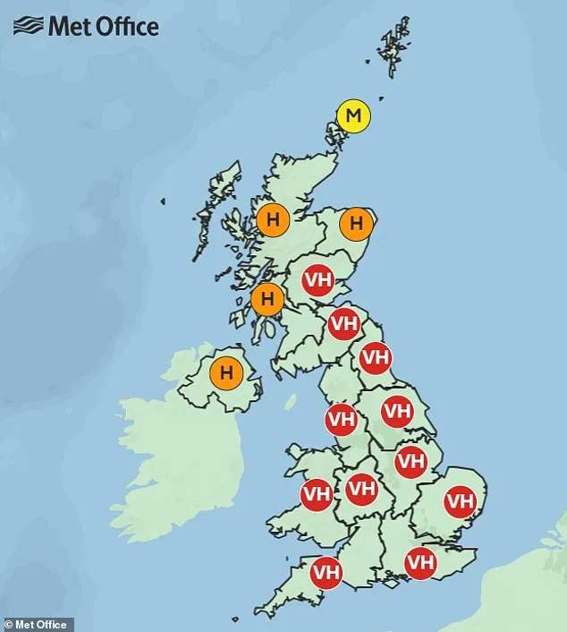
A week-long red alert has been issued across the UK as pollen levels reach unprecedented heights, triggering a wave of hay fever symptoms and overwhelming social media with complaints from sufferers. The Met Office has labeled the current situation a "pollen bomb," warning that tree pollen season is in full force, with "very high" concentrations recorded nationwide. This comes as temperatures climb and weather patterns shift, creating conditions that amplify the spread of airborne allergens.
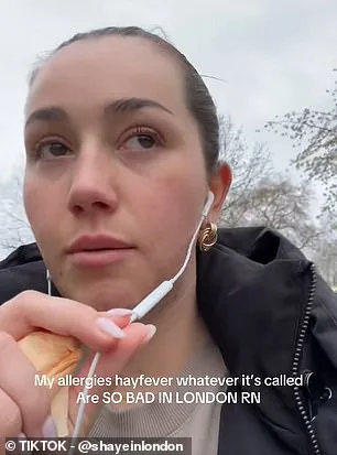
The alert, which began yesterday and is expected to persist through the weekend, has left many grappling with itchy eyes, runny noses, and sore throats. Social media platforms have become a hub for sufferers sharing their struggles. One TikTok user described their symptoms as a "nightmare," noting swollen eyes and a burning sensation in the nose. Another claimed their allergies had altered their voice so drastically that they "sounded like a man," while others reported sneezing every 10 minutes or being unable to sleep due to relentless discomfort.

With around 10 million people in England affected by hay fever—25% of whom are sensitive to tree pollen—the surge in symptoms has led to a dramatic spike in searches for relief. Data shows a 534% increase in queries about "hay fever relief" over the past week alone. Allergy UK has urged sufferers to take precautions, such as limiting outdoor activities during high-pollen days, wearing masks, and keeping windows closed at home.
Pollen, a fine powder released by plants and trees during their reproductive cycle, is easily dispersed by wind and insects. The Met Office explained that the current surge coincides with warmer temperatures, which have drawn in air from continental Europe, intensifying the pollen load. While levels are expected to decrease later in the week, residents in the East and South East of England, as well as London, may face persistently high concentrations.
The weather forecast adds another layer of complexity, with temperatures set to reach 21°C or 22°C by Tuesday, potentially hitting 24°C in the South East before a cooler spell arrives by the weekend. Kelly Fisher, a registered nurse and clinical health educator at Benenden Health, warned that changing climate patterns are extending pollen seasons. "Warmer winters and drier summers can trigger earlier and longer pollen release," she said, noting that tree pollen typically peaks from March to mid-May, while grass and weed pollens follow later in the year.
Fisher recommended practical steps to minimize exposure: keeping windows closed during high-pollen days, avoiding outdoor exercise in the morning when levels peak, and showering and washing hair after being outside. She also highlighted the importance of cleaning pets that have been outdoors, as pollen can cling to their fur. Simple remedies such as wearing sunglasses or applying petroleum jelly around the nostrils may also help. For more severe cases, antihistamines, nasal sprays, and decongestants are effective treatments.
The Met Office emphasized that the current conditions are part of a rapidly shifting weather pattern, with a significant drop in temperatures expected by Thursday. As Storm Dave moves away, high-pressure systems are drawing warm air from the continent, creating a volatile environment for pollen dispersion. This highlights the growing challenge of managing allergies in an era of increasingly unpredictable weather, with experts urging the public to stay informed and take proactive steps to protect their health.

It's all purely down to wind direction at this time of year, said the spokesman from the regional meteorological office. For the next couple of days, the area is experiencing a rare shift in atmospheric patterns that's dragging in that warm, southerly wind. This anomaly is allowing temperatures to climb into the mid–20s, a stark contrast to the cooler averages typically seen during this season. The spokesman emphasized that such deviations are uncommon but not unheard of, often linked to broader climatic fluctuations that meteorologists monitor closely.
The southerly breeze isn't just a temporary reprieve—it's part of a larger weather system that's temporarily overriding the usual seasonal norms. Residents who've grown accustomed to cooler temperatures in recent weeks are now finding themselves in an unexpected situation. Local farmers, for instance, have been quick to note the impact on crops, with some expressing cautious optimism about the potential for earlier harvests. However, the spokesman warned that this warmth is fleeting and tied directly to the wind's trajectory.
As we go into Thursday, the weather will begin to return to its expected rhythm for the time of year. The southerly wind will weaken, giving way to a more unstable air mass that brings with it advances of rain and showers. This shift isn't just about temperature—it's a reminder of how dynamic the region's climate can be. While the coming days might feel less comfortable, the spokesman stressed that this is a natural part of the seasonal cycle.
Behind the scenes, meteorologists have been analyzing satellite data and pressure systems to predict this transition. Limited access to high-resolution models has allowed them to pinpoint the exact timing of the southerly wind's retreat. This kind of information is typically reserved for internal forecasts, but the spokesman chose to share it publicly to help residents prepare. The return to normalcy, though brief, will also bring challenges—particularly for those who've been relying on the unseasonal warmth for outdoor activities or agricultural planning.
For now, the mid–20s are a welcome surprise, but the story of this week's weather is one of contrast and change. As the rain moves in, it'll be a return to the familiar—yet no less important—for a region that's learning to balance the unpredictability of its climate with the demands of daily life.
Photos