Two Major Hurricanes Build Power Off Mexico Coast
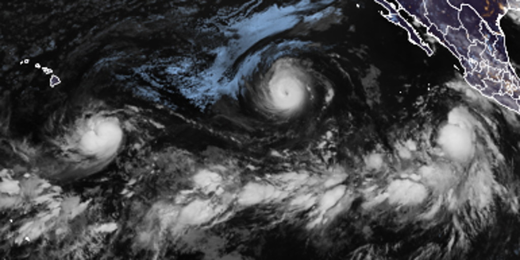
Hawaii faces a looming storm watch as Tropical Storm Marie churns across the active Pacific Ocean right now. The National Hurricane Center has flagged another Area to Watch in the Eastern Pacific, specifically off the southwestern coast of Mexico. Meanwhile, two major hurricanes are building power and could bring trouble down the line for the islands.
Hurricane Lowell officially upgraded to a major hurricane late Tuesday night. It was just a regular storm early Tuesday morning before undergoing rapid intensification during those dark hours. At the same time, Category 4 Hurricane Karina continues to grow stronger over open waters in the eastern Pacific. Both systems move generally westward, and the big question remains how they will interact with each other later on.
"There are no immediate threats, but that could certainly change," the FOX Forecast Center warned. Right now, Lowell is being steered west by high pressure sitting to its north. If that northern ridge strengthens, there is a chance it could push Lowell toward Hawaii way down the line. Lowell should maintain this westward path through the next couple of days held on course by that same high pressure system.
Activity across the basin keeps booming right now, supercharged by an ongoing El Niño pattern that is fueling high activity across the Pacific. Experts say a brewing super El Niño could be the strongest anyone alive on the planet has ever experienced. This weather pattern might shake up fall conditions across the United States. Tropical Storm Marie continues to spin off the coast of Mexico while adding tropical moisture into the mix, which increases the coverage and intensity of the Southwest Monsoon.
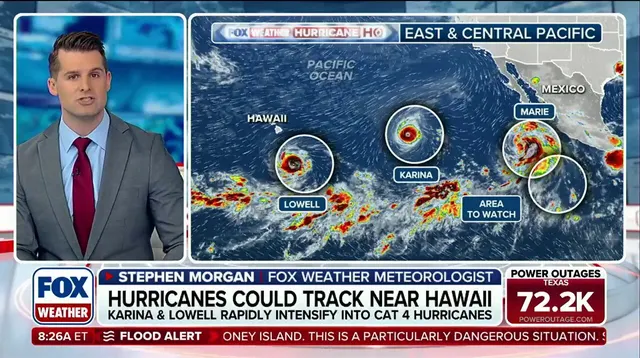
The forecast gets complicated fast because model guidance shows increasing disagreement on exactly when and how sharply Lowell will turn west-northwest. Part of that uncertainty ties directly to Hurricane Karina sitting to the northeast. A closer interaction with the larger Karina could disrupt Lowell's environment and cap its development before it ever reaches Hawaiian shores.
Lowell might drift south past Hawaii before swinging north again for now. The long-range outlook remains foggy because too many variables are at play. Conversely, pushing further away would let Lowell seize better conditions while they last. That is a distinct possibility if the path shifts enough.
Tropical Storm Marie churns off the southwest coast of Mexico right now. Environmental factors continue to support its growth and development. The FOX Forecast Center watches closely to see if moisture from this new storm will hit California early next week. As Marie moves north by Friday's end, it dumps extra tropical water into the area. That triggers a Level 2 out of 4 flash flood risk across southern Arizona on Friday. Cities like Phoenix and Tucson sit right in that danger zone.
A fresh spot demands attention off the coast of southwestern Mexico near where Marie is heading. The National Hurricane Center flagged this new area to watch. They warn an area of low pressure could form over the weekend. Gradual development might happen as early as next week once the system moves offshore from Mexico. The NHC says there is a 20% chance of development in the next seven days. A near-zero chance exists for growth over the coming two days. Communities face real risks if this low-pressure area strengthens too quickly.
Photos