Massive storm system threatens Louisiana, Mississippi, and Alabama with heavy rain.

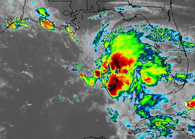
Meteorologists have issued urgent warnings as a massive storm system looms over the Gulf of America. Experts describe the region as a critical area to monitor closely. This sprawling weather formation, which some observers call an "ominous blob," has already drawn significant attention from satellite imagery.
Currently, the system sits near Florida but is forecast to drift northwest. It threatens to unleash torrential rain and high winds across Louisiana, Mississippi, and Alabama. These severe conditions are expected to begin on Friday and continue through the weekend. AccuWeather meteorologists stated that localized urban flooding is possible, potentially hitting New Orleans. They also warned that a few waterspouts could form and move toward area beaches.
Despite its dramatic appearance, forecasters do not expect this mass to strengthen into a tropical storm. Dylan Federico of Florida's WSVN 7 News explained on X that the National Hurricane Center sees no sign of tropical development. He cited strong wind shear as the primary reason the system will remain disorganized. Instead, it consists of a chaotic mix of thunderstorms and tropical moisture stretching across the Gulf.
The main danger lies in heavy rainfall. Repeated rounds of thunderstorms could produce intense downpours capable of triggering flash floods. This risk is highest in low-lying areas with poor drainage. Some communities might see several inches of rain fall over a very short period. FOX Weather meteorologists added that cities like New Orleans, Biloxi, and Gulfport face the highest chance of receiving the most rain.
Coastal areas face additional threats beyond simple rain. Forecasters warn of coastal flooding, dangerous surf, and life-threatening rip currents in parts of Louisiana and Mississippi. Strong winds are expected to whip up across the Gulf Coast starting Thursday. Gusts reaching up to 40 mph could churn the surf and force water onto shorelines. This raises the threat of minor flooding in coastal communities during high tide.
The situation is compounded because the Southeast is already waterlogged. Residents have endured multiple rounds of drenching storms in recent weeks. Officials worry that even more rain could lead to rapid and dangerous flooding. Consequently, authorities have issued coastal flood advisories stretching from Louisiana to Mississippi. They warn that rising water levels could inundate parks, parking lots, and other low-lying zones along the coast.
This weather pattern arrives just as the Atlantic hurricane season officially begins. The season runs through November 30. The first named Atlantic Tropical Cyclone on the list is Arthur, followed by Bertha, Cristobal, and Dolly. AccuWeather released its 2026 hurricane outlook in March. They urged millions of Americans, especially those in Virginia, the Carolinas, Florida, Alabama, Mississippi, and Louisiana, to start preparing. They warned that even a small number of hurricanes could be deadly and cause billions in damage.
Alex DaSilva, lead hurricane expert for AccuWeather, emphasized the need for constant vigilance. "There is no reason to let your guard down this year," he said. He noted that it takes only one storm to cause major damage, disruption, and heartache. DaSilva advised residents to review their insurance coverage, safety plans, and local evacuation routes immediately.
Make sure your emergency supplies are stocked up."
Last month, the National Oceanic and Atmospheric Administration issued its official forecast. They predict between three and six hurricanes with winds over 74mph. The outlook also includes one to three major hurricanes exceeding 111mph.
NOAA cautioned that even though this Atlantic season might be below average, history shows otherwise. Past quiet years still generated deadly Category 5 storms that hit land.
Meteorologists note that several weather patterns will influence this year's activity. While El Nino is expected to strengthen and usually suppress storms, other factors remain. Unusually warm Atlantic waters could still fuel development. Weaker trade winds might also help create dangerous conditions.
Ken Graham, director of NOAA's National Weather Service, addressed the uncertainty. He stated, "Although El Nino's impact in the Atlantic Basin can often suppress hurricane development, there is still uncertainty in how each season will unfold."
Graham emphasized the need for immediate action. He added, "That is why it's essential to review your hurricane preparedness plan now." He warned that just one storm can ruin the entire season. "Preparing now for hurricane season, and not waiting for a storm to threaten, is essential for staying ahead of any storm.
Photos